Kosmos and Cairn have renewed their licence - but did San Leon Energy abandon one of its licences? A new map from ONHYM suggests changes to the highly controversial oil exploration in the occupied territory.
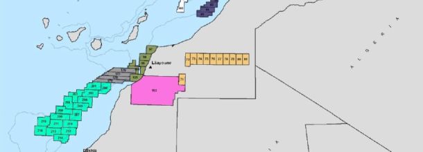
A new map has appeared online, made by the state owned Moroccan oil company ONHYM on 24 June 2016. As the oil licence maps on ONHYM's own website has not been updated for more than a year, this new map suggests three new developments.
- Kosmos and Cairn have renegotiated their offshore agreement. In April 2016, it was known that the duo Kosmos Energy and Cairn Energy were renegotiating the terms for their work offshore occupied Western Sahara. It was also stated that their new licence would be renamed to 'Boujdour Maritime'. That process seems now to have been concluded.
The new licence appears slightly larger than before, by stretching further offshore into the south west.
- What happened to the San Leon Energy block called Tarfaya Onshore? San Leon Energy has had interest in the block since 2008, a block that was partially in occupied Western Sahara and partially on the territory of Morocco proper. From September 2014, San Leon has been operating the block with 75% interest. On the recent map, the entire block is no longer appearing at all. San Leon Energy's own website does not reflect any change, and the company still claims to operate the block.
San Leon in 2015 carried out the first drilling onshore in the history of occupation. In October 2015, thousands of refugees protested the operations of the company on that block.
- Now we know the shape of the Lemsid block. Since 2015, it has been known that ONHYM had carved out a new area for the oil companies, named Lemsid. WSRW wrote about that in June 2015. From 2016, the exploration activities were observed on the ground, carried out by the Polish company Geofizyka Kraków. WSRW wrote a report about the affair on 28 June 2016. However, the exact borders of the block was only known now. It is not known who is operating the Lemsid block. WSRW guesses it could be ONHYM itself.
The map is called "Permit map - June 2016" and appears in a document written on 24 June 2016 which was published on the website of Oil and Gas Council. See also a similar presentation by ONHYM given to the same institution in 2015.
Morocco has occupied the larger parts of Western Sahara since 1975, and the UN has stated that any further oil exploration is illegal unless it takes place in accordance with the wishes of the people of the territory. The oil companies involved have made no efforts to seek the consent of the Saharawi people.
The world's biggest sovereign wealth fund the last months dropped investments in San Leon Energy, Cairn Energy and Kosmos Energy over concerns of international law.
Kosmos and Cairn have pulled out of Western Sahara
17 years of US private company engagement in exploring the oil potential of Western Sahara has come to an end.
Kosmos surveying oil potential near Dakhla again?
Over the past 24 hours, WSRW has observed a resumed seabed exploration north of Dakhla, in the block operated by American oil company Kosmos Energy in collaboration with Scotland's Cairn Energy.
Kosmos/Cairn oil study in occupied waters has ended
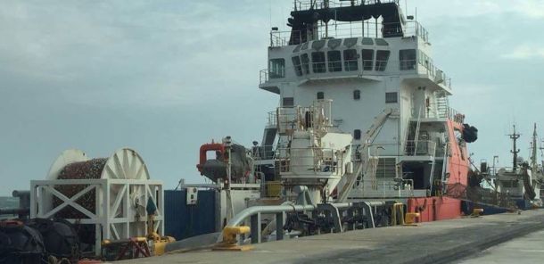
Here is Kosmos Energy's supply vessel in occupied Western Sahara
Kosmos and Cairn Energy are exploring for oil offshore Western Sahara, occupied by Morocco. This photo taken yesterday shows one of their supply vessels.


